
: failed to open stream: Invalid argument in <b>/home/servuzmq/minisites/siteT1/common/template/carteV2.php</b> on line <b>139</b><br />
)
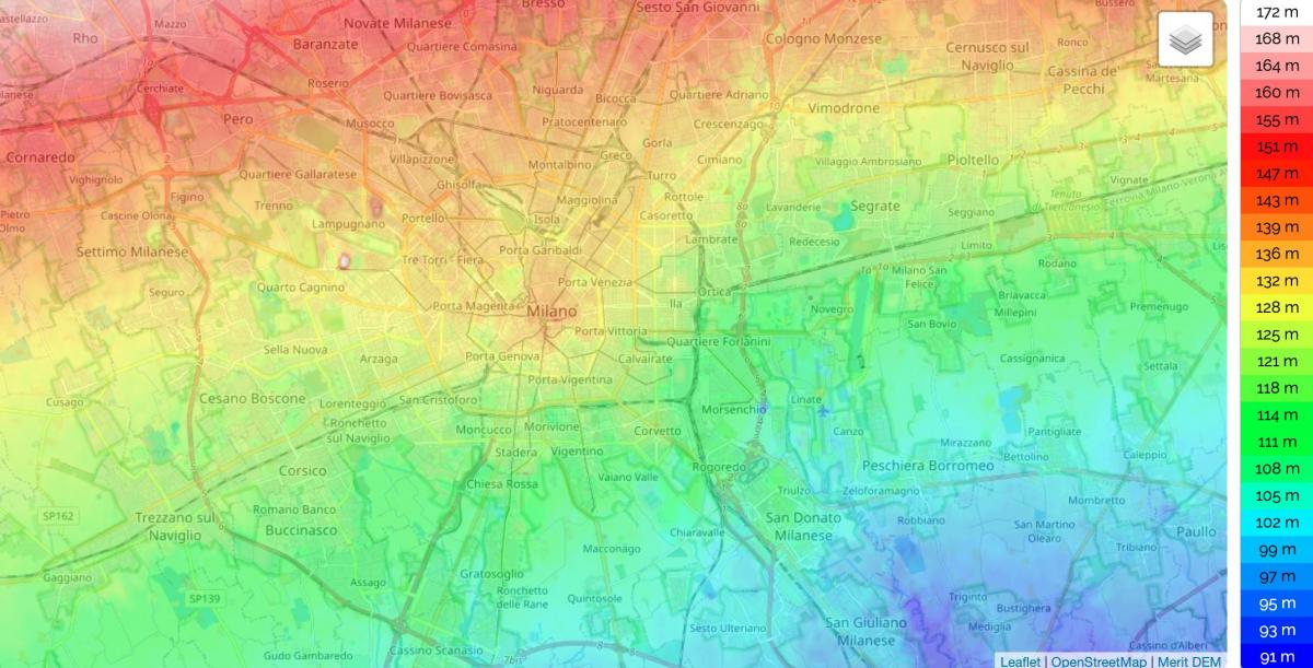
You can find on this page the Milan topographic map to print and to download in PDF. The Milan elevation map present the topography, river and relief of Milan in Lombardy - Italy.
The Milan topographic map shows elevation, hills and landforms in Milan. This elevation map of Milan will allow you to know topography, river and relief of Milan in Lombardy - Italy. The Milan topographic map is downloadable in PDF, printable and free.
Milan is set in the heart of the Po Basin of northern Italy, halfway across the immense plain spreading between the Ticino and Adda rivers. The site is 400 elevation feet (122 metres) above sea level as you can see in Milan elevation map. To the north lies the great sweep of the southern flank of the Alps. Between this semicircle of mountains and the course traced by the Po River to the south, there lies a zone that is arid toward the north but swampy near the Po, where it turns into an expanse of marshy groves and rice fields. It is at the line of demarcation between these two areas, which are strongly differentiated, that Milan has risen, although now only swamplands mark the site of the ancient city. The earliest inhabitants reinforced their defenses by means of the small watercourses of the Sèveso, the Nirone, the Lambro, and the Olona.
There are 4 named mountains in Milan. Monte Stella is the highest elevation point. The most prominent mountain is Collina della Croce. Monte Stella ("Starmount") as its shown in Milan elevation map, also informally called Montagnetta di San Siro ("Little mountain of San Siro") is an artificial hill and surrounding city park in Milan, Italy. The park, established in the 1950s, has an overall area of 370,000 m². The hill is 45 m high; according to the original design, it should have been twice as high, but it was later redesigned to avoid damaging buildings in the nearby street Via Isernia as a consequence of side pressure. Even at only 25 m height, the hill provides a panoramic view of the city and hinterland, and in a clear day, the Alps and Apennines can be distinguished from atop.
Milan is snuggled up in the lower plains of the Padana in the west-central Lombardy region of Italy as its mentioned in Milan elevation map. The rivers of Ticino, Po and Adda are an integral part of Milan province which is the first releases of the alpines. Milan occupied a total area of 181 sq.kms with a sea level rise elevation of 122 mtrs. The Milan city and metropolitan areas form the core industrial principal towns in Italy.
