
: failed to open stream: Invalid argument in <b>/home/servuzmq/minisites/siteT1/common/template/carteV2.php</b> on line <b>139</b><br />
)
You can find on this page the Milan streets map to print and to download in PDF. The Milan roads map presents the road network, main roads, routes and motorways of Milan in Lombardy - Italy.
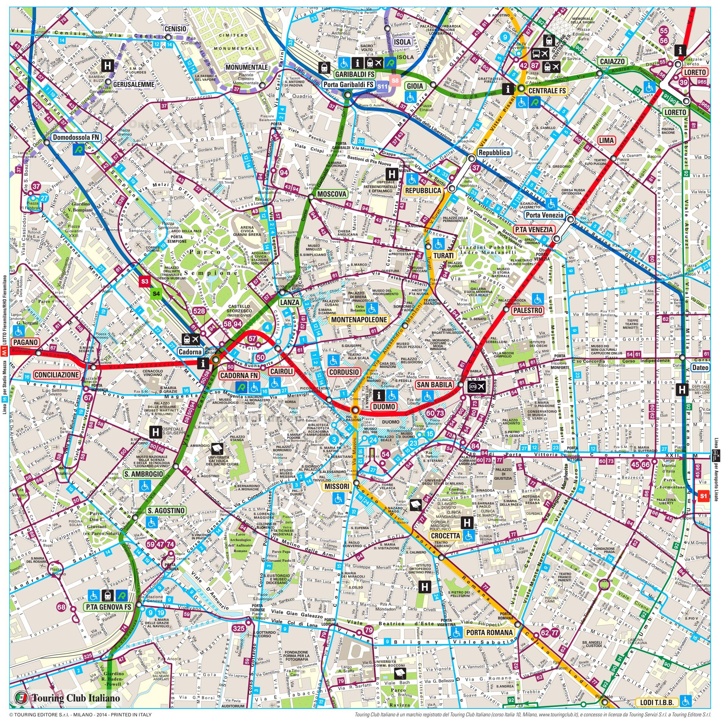
The Milan streets map shows all street network and main roads of Milan. This streets map of Milan will allow you to find your routes through the streets of Milan in Lombardy - Italy. The Milan streets map is downloadable in PDF, printable and free.
Via Montenapoleone is located in the middle of Milan and it is part of the famous high-fashion district known as the “Quadrilatero della moda” that also includes Via Manzoni, Via Della Spiga and Corso Venezia. Its name dates back to the Napoleonic era when it was the seat of the financial institution Monte Napoleone for the management of the public debt. The street dates back to the 18th-19th century and its style is mostly Neoclassical as its mentioned in Milan streets map. Via Dante is the straight street aligned with the exit of the Castello Sforzesco and it was planned, together with piazza Cordusio and Foro Bonaparte, during the Napoleonic era. At early 19th century a street connecting the castle to Piazza Duomo was planned but the works only started in 1884, when the piano Beruto was approved.
Corso Vittorio Emanuele as you can see in Milan streets map is a popular shopping street lined on both sides with boutiques specialized in clothes and accessories, situated behind the Milan Cathedral and connecting Piazza Duomo with Piazza San Babila. Named after Vittorio Emanuele II, the first King of unified Italy, this is the second largest pedestrian area in downtown Milan, ideal for shopping and passing time away. Stemming from here are a number of small covered shopping galleries emerged during the post-war renovations. Other than luxurious shops selling latest collections of Gucci, Louis Vuitton, Prada and other top brands, the passage houses a number of cinemas, restaurants and cafes equally worthy of one time and money.
Via Manzoni is a busy and fashionable street in Milan which leads from Piazza della Scala north-west towards Piazza Cavour. This impressive refined-air street is lined with aristocratic apartment blocks and opulent churches. Corso Venezia is one of the city most exclusive and elegant avenues, being part of the city upscale Quadrilatero della moda shopping district, along with Via Monte Napoleone, Via della Spiga, Via Sant' Andrea and Via Manzoni. It also boasts a great collection of historic palaces, parks and gardens. Corso Buenos Aires is yet another major thoroughfare in Milan. With over 350 shops and outlets, this is one of the busiest streets in the city. It is also the longest shopping artery of Milan, stretching for about 1.2 km from the Duomo to the nearby city of Monza as its shown in Milan streets map.
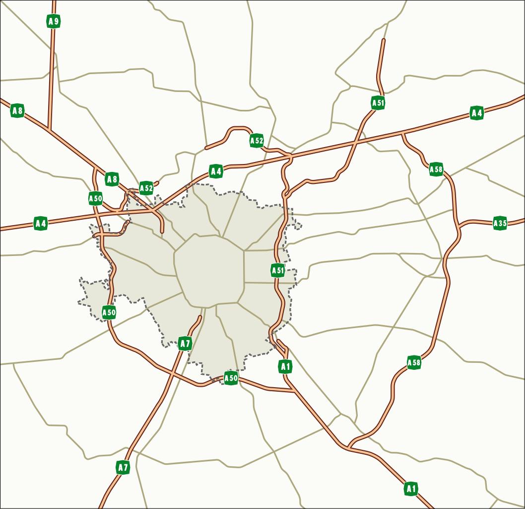
The Milan roads map shows all road network and highways of Milan. This roads map of Milan will allow you to find your routes through the roads and motorways of Milan in Lombardy - Italy. The Milan roads map is downloadable in PDF, printable and free.
The Lombard capital, known not only for its fashion, luxury and entertainment, has become the heart of the Italian economy. The city of Milan can in fact be defined as the second capital of Italy and, as in every capital, road traffic is sovereign. Milan LTZ is formed by the B Area and the C Area as you can see in Milan roads map. The B Area is the area delimited by the red lines in the map above. The time slots in which is active are: From Monday to Friday, excluding public holidays, from 7:30 am to 7:30 pm. The C Area, with its 43 entrances located around the Cerchia dei Bastioni, delimits the historical centre of Milan.
In 1964 Italy completed the Autostrada del Sole, stretching almost 500 miles (800 km) from Milan to Naples as its shown in Milan roads map, to which numerous branches, spurs, and extensions were added. Other European countries and Japan also built express highways. Since most goods in Italy are transported by road, the system is constantly upgraded and improved. It provides a highly developed and efficient network of interconnected highways and lesser roads, particularly in northern regions. The main routes at the hub of the road system are Turin-Milan-Venice-Trieste, Milan-Bologna-Florence-Rome, Milan-Genoa, and Rome-Naples.
The Pedemontana Lombarda Motorway (Autostrada Pedemontana Lombarda) project involves the construction of 67km of motorway, 20km of bypass roads and 70km of road connections to solve congestion in the north of Milan, Italy as its mentioned in Milan roads map. The motorway will connect five provinces, including Bergamo, Monza e Brianza, Milan, Como, and Varese. The project is regarded as a strategic work of national importance to further boost the economic and regional development of these provinces, which are home to approximately 300,000 businesses and generate approximately 10% of the national GDP.